")
")
")
")
")

")
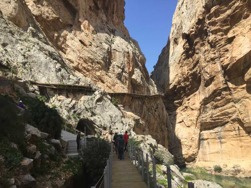
Camino del Rey
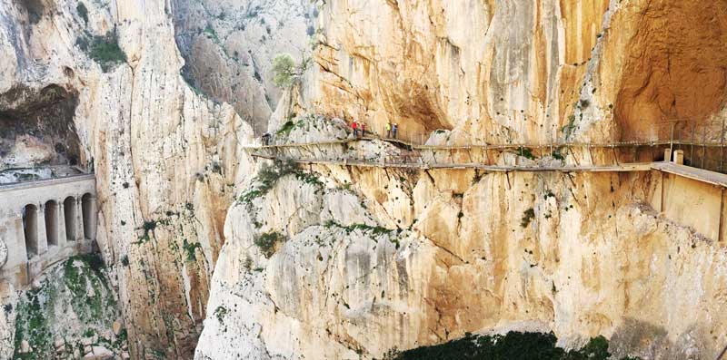
The famous Caminito del Rey lives up to its reputation as being the ‘one of the hottest new travel experiences for 2015’ (Lonely Planet). It is a spectacular walk through some of the most picturesque countryside in Andalcuia. Having originally been labelled as one of the scariest walkways in the world, it is now easily accessible and has plenty of safety procedures in place. The renovation began in 2011 and it is now open to the public. The Kings walk was built over a hundred years ago to bring the workers from the hydroelectric dam through the Gorge. Nowadays it is more a pleasure activity and is accessible to all fitness levels.
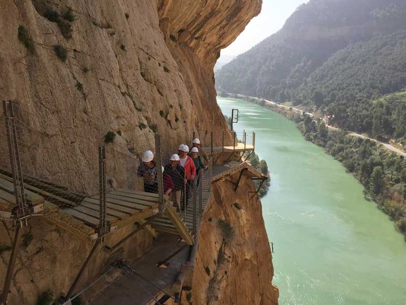
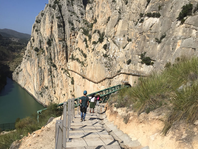
There is a possibility to enter from our village of El Chorro or from Ardales. It is possible to walk to the entrance of the Caminito del Rey from our site (approx. 2 kilometres) In total the walkway is 7 kilometres long and it can take anything between 2 and a half hours and 4 hours. It is a linear walk which finishes at the beautiful ‘Pantanos de El Chorro’. From here there is a bus which will bring you back to El Chorro. The cost is 1.70 euro. The timetable is following this link.
Currently the walkway is run by Campano S.L Ardales, you can book tickets trough their website www.caminitodelrey.info However it can be quite difficult to obtain these tickets. For more information regarding our accommodation, please email us or have a look on our website.

Climbers have free entrance to the area when they show their climbing club membership. (not on weekends) Only the routes below the Camino and the opposite side of the Camino are allowed to be used. There is an upcoming project to renovate the routes in the gorge.
Essential information for your trip:
- The walkway is closed on Monday
- Opening hours are 10.00 -14.00 (Winter) and 10.00 – 17.00 (Summer)
- Children under 8 years of age are not allowed.
- Dogs are not allowed.
- Toilets are available at the beginning and end of your trip but not within the gorge.
- Take your rubbish out with you.
- Umbrellas and ‘selfie’ sticks are not allowed.
- Parking is available in the village of El Chorro
Historical Background
In 1901 the works to build the canal started as well as the works to build the service bridge for the floodgate workers and guards. These spectacular works were completet in 1905 and the El Chorro Water Power Station started to produce electric power from his first station. However, besides its industrial and tecnological importance (as the works were completly avant garde for their time.) It was the bridge hanging over the impressive gorge that attracted the most attention.
Los Balconcillos was the original name given to this bridge hanging at one hundert meter above the ground. It was designed by Rafael Benjumea and his specialised team of workers. Many of these workers were sailors who were accustomed to climbing ropes and working only an abyss below them. Metallic wall brackets were used to support a brick and cement facing arch. A series of iron cross members and a simple rail were sufficient protection for the three kilometer long vertigo.
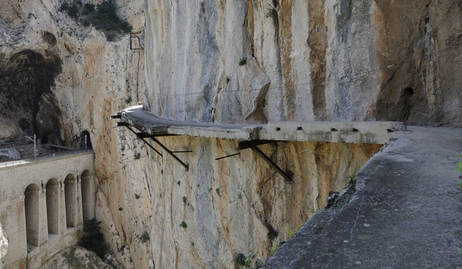
The name changed to Caminito del Rey when Alfonso XIII walked across this bridge on his way back to the Pantano del Chorro. A plaque at the entrance conmemorates the monarchys excitment and the recognition to Benjumea. This spectacular construction attracted many people and became a tourist destination, but unfortunately had also started to deteoriate due to neglect by the hydroelectric companies. Today, this construction is one of the most important restoration projects.
The gorge Desfiladero de los Gaitanes is the mayor feature of the Natural Reserve. The landscape is dominated by steep slopes, vertical gorges and deep gullies. Three rivers coming from the north of the province converge in the upper part of the caminito del rey. Each river has a dam within its own reservoir and and the water feeds into the Guadalhorce river which merges in to the Mediteranean close to Malaga.
The river often has a milky color and certain turbidity as a result of suspended sediments. It is mainly caused by clay and gypsum materials from the regions of Guadalteba and Antequera which also increase the salinity of the water. Close to the canyon the three rivers flow trough sandstone and limestone conglomerate of the Miocene age. The water contains lots of sand grains and limestone pebbles which together with the steep river slope and high water level after heavy rainfalls generate a massive erosion of the soil.
The landscape is mainly overlaid by limestone and dolomite of the Jurassic age bedrocks characterised by gray and red colors. This sedimentary rocks of marine origin where folded and fractured during the Alpine Orogeny, modifying its original horizontal stratification. The river has carved out to different sheer gorges. Gaitanejos in the north and Gaitanes in the south.